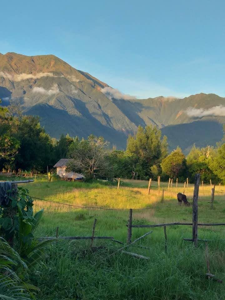
The sun was rising behind the thin outlines of Mt. Guiting-Guiting. The panorama of the mountain stood tall above the stillness of sea and clouds. In the villages below, roofs made of galvanized sheets and thatches of nipa started to appear. The soft breeze swayed the dew-drenched rice fields and coconut palms. The wild grass glimmered and beckoned towards the east. I woke up smelling the aroma of roasted rice coffee as the cocks crowed.
Located in Romblon Province, in the central Philippines, Sibuyan Island is home to Mt. Guiting-Guiting. Such was the name of the mountain because in the local vernacular, it meant “jagged,” or “saw-toothed” because of its serrated ridges. Sibuyan Island had never been linked to any of the other land mass and had remained undisturbed by life-threatening tectonic movements over thousands of years. The island is surrounded to the west by the Tablas Straight and to the east, by the Sibuyan Sea. Every year, turbulent storms, as many as the letters in the alphabet, had come and gone. But the island, not bigger than the Seychelles, was as resilient as its people.
MG2, as I called it with endearment, made history when in 1945, a US Mitchell B-25 bomber was known to have flown over MG2 and disappeared without a trace, only to be found half a century later. The wreckage was clinging to the slopes of MG2. In the 70’s, a catastrophic landslide washed out hectares of trees, and thick mud flooded the lowlands. Livelihoods were destroyed, and the villagers were devastated. No fatalities were known, but the landslide left a wide indelible scour on the terrain.
The mountain posed significant challenges to mountaineers and adventurers. There were no known ascents until 1985 when mountaineers from the University of the Philippines ventured onto the steep slopes of MG2. Stories spread later on that when the evening approached, the mountaineers, after a long trek, had camped on a vast clearing. The spot where they rested turned out to be a wide riverbed that dried out over the hot summer. Tropical nights have always been serenaded by chirps and croaks, especially in the darkness of the forests. But on that night, rain poured, and lightning struck almost without warning. Floods cascaded, overflowing giant vein-like rivers to the brim. The deluge gobbled up the exhausted mountaineers to their death. After days of attempted rescue, their bodies were found in the lower slopes of the mountain.
In spite of the ferocity of nature, the mountain was a world of many waterfalls, and an amazon of diverse ecology of flora and fauna. Some species were endemic to the island – evidence that the island has never, in its history, been connected to any other islands. The mountain had gained reputation and prominence that continued to impress conservationists, naturalists, biologists, foresters, and of course, politicians. They worked together in promoting the mountain’s protection. In effect, MG2 was proclaimed a Natural Park in 1996.
Viewed from the east, the breathtaking 2,058-meter-high mountain was clear, sharp, and dramatic. Viewed from the west, the broccoli-like slopes contrasted with the moss-and-red-mud summit. My imagination could only branch out wildly into the backwoods and up the peak of the mountain. The summit was adorned with sporadic prairies and heath, but the absence of trees underscored the thin atmosphere at the top. When I tried to think of it, MG2 was more striking and panoramic when viewed from the western plains bordering the island. The mountain stood in grace and majesty as if it wanted to reach up high and embrace its Creator. The island had three towns, namely, Magdiwang in the north side, Cajidiocan in the east, and in the west was my hometown, San Fernando.
Rainfall was intense from July to October, swelling up rivers, streams, and falls, replenishing the soil and sustaining the lowlands. Among the great rivers was Cantingas which stretched for kilometres from the slopes of MG2.
When I was a small kid, my mother and I went to the town. There were no bridges in some of the rivers, so we had to get-off the to ease the load on the jeepney, a local bus. Passengers had to walk across the river which, it seemed to me, as wide as the ocean. Everything was grey on that day, as fuzzy as I remembered.
I looked up and saw raindrops started dropping like little bubbles over us. “What is that?” I blurted out.
Nanay tightened her grip around my arm. “Walk! And be quiet.”
It seemed to me that we were in a no-man’s land. I could hear the gurgling of the stones that were continuously swept by the current, swirling around my feet. The river clamoured as if summoned by God into the sea. The river was cold, knee-deep, rocky, and alive. I kept my mouth shut and continued to tread with my bare feet. When everyone had crossed, we again boarded the jeepney, and were able to reach the town after an hour-long journey.
Dry season set in from February and lasted until April. Monsoon season usually began in May and continued until November as the climate became cooler towards December.
Early summer afternoons in the tropics were a delight. As humidity rose, the mountain showed its rough lines in a mixture of green, amber, and mud-red. Mt. Guiting-Guiting disappeared later while the neat, immaculate, motionless cotton clouds descended. Wilderness intertwined in peace and quiet. **


